File:Oldtidens Israel & Judea.svg
Jump to navigation
Jump to search

Size of this PNG preview of this SVG file: 501 × 599 pixels. Other resolutions: 201 × 240 pixels | 401 × 480 pixels | 642 × 768 pixels | 856 × 1,024 pixels | 1,713 × 2,048 pixels | 726 × 868 pixels.
Original file (SVG file, nominally 726 × 868 pixels, file size: 107 KB)
Captions
Captions
Add a one-line explanation of what this file represents
Summary[edit]
| Description |
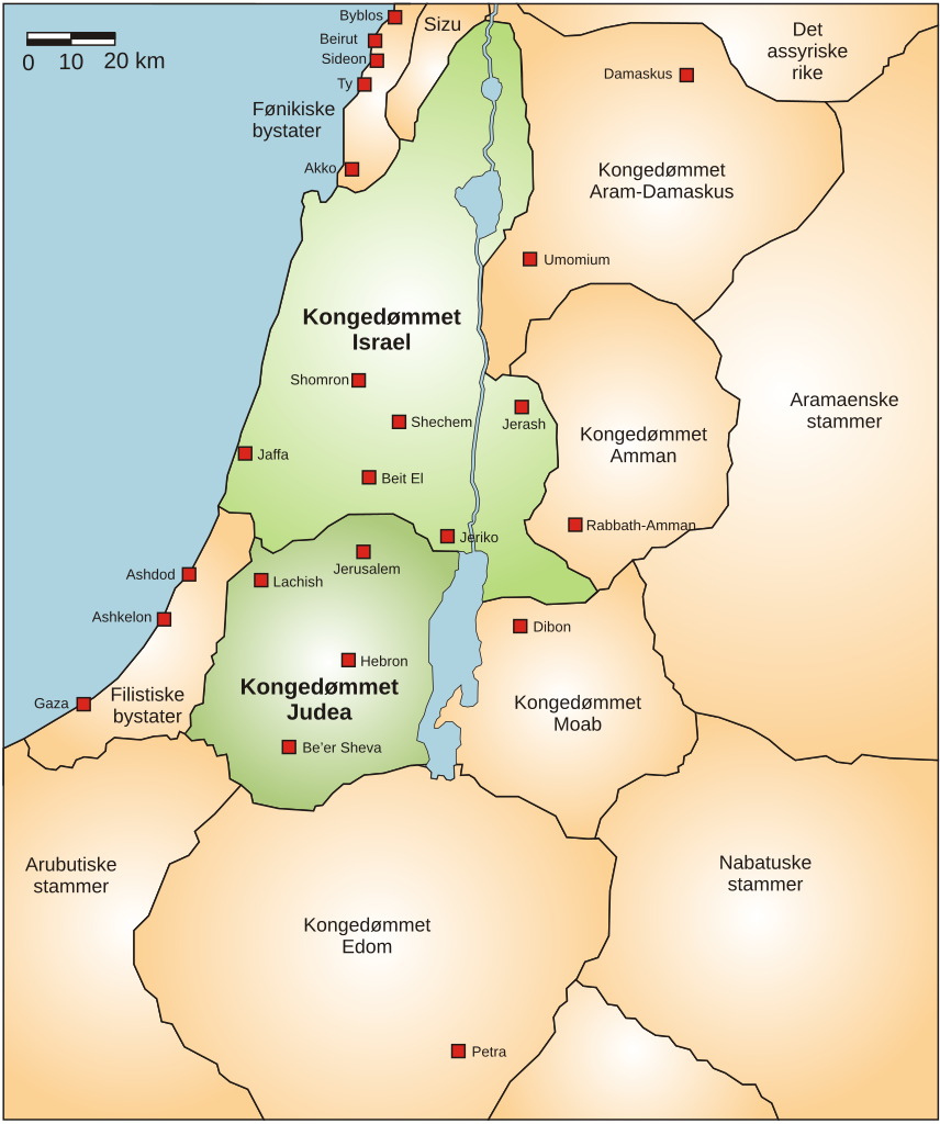
English: Map showing the ancient levant borders & ancient cities such as Urmomium & Jerash. The map also shows the region in the 9th century BCE. Notice the coastal land of Philistia, from which the name "Palestine" derives. based upon Levant 01.PNG, but translated to SVG & Norwegian. |
| Date | |
| Source | Own work |
| Author | FinnWikiNo |
| Other versions |
Derivative works of this file: Kingdoms of Israel and Judah map 830.svg  |
Licensing[edit]
I, the copyright holder of this work, hereby publish it under the following licenses:
This file is licensed under the Creative Commons Attribution-Share Alike 3.0 Unported license.
- You are free:
- to share – to copy, distribute and transmit the work
- to remix – to adapt the work
- Under the following conditions:
- attribution – You must give appropriate credit, provide a link to the license, and indicate if changes were made. You may do so in any reasonable manner, but not in any way that suggests the licensor endorses you or your use.
- share alike – If you remix, transform, or build upon the material, you must distribute your contributions under the same or compatible license as the original.

|
Permission is granted to copy, distribute and/or modify this document under the terms of the GNU Free Documentation License, Version 1.2 or any later version published by the Free Software Foundation; with no Invariant Sections, no Front-Cover Texts, and no Back-Cover Texts. A copy of the license is included in the section entitled GNU Free Documentation License. |
You may select the license of your choice.
File history
Click on a date/time to view the file as it appeared at that time.
| Date/Time | Thumbnail | Dimensions | User | Comment | |
|---|---|---|---|---|---|
| current | 16:10, 30 January 2010 | | 726 × 868 (107 KB) | FinnWikiNo (talk | contribs) | {{Information |Description={{en|1=Map showing the ancient levant borders and ancient cities such as Urmomium and Jerash. The map also shows the region in the 9th century BCE. Notice the coastal land of Philistia, from which the name "Palestine |
You cannot overwrite this file.
File usage on Commons
There are no pages that use this file.
File usage on other wikis
The following other wikis use this file:
- Usage on da.wikipedia.org
- Usage on nn.wikipedia.org
- Usage on no.wikipedia.org